


RSN
The catastrophic earthquakes that have occurred in Italy and around the world have taught us that rapid and precise information on the location of the epicenter and the magnitude of the seismic event is essential so that the Civil Protection can organize first aid in the affected areas.
Historically, the INGV monitoring network was born and took shape in the early 80s, following the Irpinia earthquake of November 23, 1980 (fig.1)
The figure shows a map of the RSNC, dating back to the early 90s. At the time, the network was exclusively of the analogue type and included about 70 stations with only vertical sensors with the exception of a few sites, where the 2 horizontal sensors were also mounted to obtain the complete motion of the ground.
At the time, the transmission of the seismic signal was entrusted to a system which provided for the use of purely analogical electronics: an amplifier of the signal coming from the sensor and a modulator for the transmission on the always active telephone line, which connected the remote station with the operations room in Rome, where the signals were demodulated and recorded.
At the time the seismic data were recorded on thermosensitive paper (seismograph) and the arrival times of the various seismic waves were read by hand (with a ruler from the seismograms) and manually loaded onto the epicentral calculation system.
Assuming that the time required for transmission from the various stations was practically nil or in any case irrelevant from the point of view of the location of the seismic events, the timing of the seismic signal took place directly in Rome, where the reception of the signals was associated with the "international ” initially generated by an atomic clock and later by a professional GPS.
Seismic trace digitization was implemented in the early 90s.
In the mid-90s, advances in technology brought about radical changes in both the acquisition and transmission and recording of RSN data. We pass from one-component sensors to three-component sensors and extend both the frequency band and the dynamics of the recorded signal, the acquisition systems pass from analog to digital, with the first 24-bit digital stations, the brand of the time it is associated with the seismic signal on site through a special GPS receiver and finally the transmission continues to be on telephone cable, but digital and no longer analogical.
The transition from analog to digital has brought a series of advantages, such as the elimination of the uncertainties and errors due to the transmission of the non-timed analog signal, the increase in dynamics from 60dbm to 130dbm and the perfect calibration of the signals and of the acquisition chain . It was consequently possible to define the Magnitude more precisely,
passing from the Magnitudo-Duration taken on the Paper Rolls to the far more reliable calculation of the Magnitudo-Gutenberg Richter, based on the reading of the amplitudes of the S waves.
Given the huge costs of digital data acquisition devices, at the end of the 90s the INGV laboratories designed and developed a data acquisition tool called GAIA, now in use on most of the RSN.
Alongside the telephone-type transmission vector, the first satellite connections appeared at the beginning of the 2000s and later also UMTS and WiFi. The differentiation of the transmission vectors increases the robustness of the RSN, no longer dependent on a single transmission system. Furthermore, accelerometer sensors and geodetic GPS were progressively combined with the seismic velocimetric sensor, giving way to what would become within a few years the modern and current multiparametric National Seismic Network.
To date, the National Seismic Network consists of about 500 stations scattered throughout the country, all teletransmitted to the INGV Seismic Room, where a 24-hour localization and evaluation service of the magnitude of seismic events that occur in Italy is in operation. in order to allow seismic monitoring of the national territory, one of the main institutional tasks of INGV.
Most of the stations are managed directly by the personnel of the various INGV offices, but thanks to the current communication possibilities provided by new technologies and the Internet, the RSN is enriched by the stations of various other Italian and foreign networks.
The following Organizations contribute to the RSN:
-
the network of North Western Italy Lunigiana and Garfagnana, managed by the Department of Earth, Environmental and Life Sciences of the University of Genoa (DISTAV, network code GU);
-
the broadband network of North Eastern Italy managed by the Seismological Research Center (CRS) of the National Institute of Oceanography and Experimental Geophysics (OGS-CRS, Network Code OX);
-
the regional networks of Trentino (network code ST) and Alto Adige (network code SI);
-
the network of the Marche Region;
-
the Alta Val Tiberina network (TABOO project);
-
the Lardarello network;
-
the Irpinia network;
-
the network of the University of Calabria.
The complete list of the stations of the National Seismic Network, managed by INGV and of the other regional and local networks managed by other Bodies is available on the page https://www.ont.ingv.it/monitoraggio-e-sorveglianza/la-rete-sismica-nazionale/sviluppo-della-rsn).
The Seismic Network is a constantly evolving structure, both the acquisition and transmission systems change and improve, the number of stations increases, backup systems are prepared to ensure both reception and archiving of data.
The constant technological developments implemented in recent years have brought about a significant improvement in monitoring, allowing on the one hand to significantly lower the network detection threshold and on the other to drastically reduce processing times for the complete usability of the information, both Civil Protection purposes, and for scientific research purposes.
To date, on most of the national territory we are able to locate events from magnitude 1 upwards, while in areas where the network is more sparse we are still able to determine seismic events from magnitude 2 upwards. There are also areas characterized by a higher density of stations, where our detection threshold is well below Magnitude 1.

The INTEGRATED NATIONAL GPS NETWORK (RING)

Fig.1: Distribution of RING network stations.
Fig. 2 - Examples of geodetic monuments used for the RING network. A) complete RING station, B) antenna mounted on reinforced concrete pillar, C) antenna mounted on surface tripod, D) antenna mounted on building.
The monitoring of ground deformations through networks of Global Navigation Satellite System (GNSS) stations is one of the main institutional tasks of INGV. Globally, the data provided by the GNSS networks have allowed a significant step forward in the knowledge on the processes of accumulation and release of deformation during the various phases of the seismic cycle. The reasons that led to the creation and continuous densification of the RING network are linked to the need to better understand the rates and directions of displacement of the crustal blocks that make up the complex tectonic mosaic of the central Mediterranean, and to measure, in greater detail spatial possible, the deformation rates along the Apennine and Alpine chains, where most of the seismic energy release in our country is concentrated.
The RING network is currently made up of 207 GNSS stations active in Italy, Greece and Malta (Fig. 1). The network has been installed since 2004 for monitoring ground deformations in non-volcanic areas. In fact, the RING is associated with denser GNSS networks for monitoring active volcanoes. The RING network was created as part of various agreements and projects, many of which are now closed; among these, the agreements with DPC 2004-2006 and 2007-2009, the PROSIS and FIRB projects financed by MIUR, the APQ Sicily and recently the Otrions project and the PON Vulcamed. As part of the PON-Grint project, starting from 2019, a significant upgrade of the instrumental park is planned, as well as a densification of the network.
The RING is managed by personnel belonging to various sections, and in particular to the National Earthquake Observatory (ONT), the Bologna Section, the Etna Observatory (OE) and the Vesuvius Observatory (OV). In particular, the maintenance and management of the RING is coordinated by the Geodetic and Seismic Observatory of Grottaminarda which makes use of contributions from the Rome and Bologna offices for central and northern Italy and the Ancona office for the Umbria-Marche area, from 'OV and from the OE, however, for the GPS stations of Sicily and the Campania area respectively. The installation of RING stations in Greece and Malta are the result of scientific collaborations respectively with the National Observatory of Athens and the University of Malta.
Almost all of the GNSS sensors installed transmit data, both in real time and in near real time, at the offices in Rome, Grottaminarda and Ancona. The transmission system mainly makes use of satellite vectors (TCP/IP, UDP, VSAT, Broadsat) and internet or intranet connections, wired or wireless (Wi-Fi and GPRS/UMTS).
Given the geological complexity of the Italian territory, the stations of the RING network have been built over the years using different types of geodetic monuments. Fig. 2 shows some examples. Most of the stations in the RING network were built using a steel surface tripod (https://webring.gm.ingv.it/index.php/ring-infrastructure/#sites).
The quality control and archiving of the GPS data and related information is done in the RING database which is an advanced technological infrastructure aimed at the complete management and sharing of data and related information content. The GPS data of the RING stations, available to the entire scientific community (https://webring.gm.ingv.it:44324/rinex/RING), are processed, together with the data of the other networks operating on the national territory, by three Analysis Centers organized to guarantee processing according to the international standards defined by the International GNSS Service (IGS) and contained latency times, compatibly with the availability of IGS products required by daily data and processing software.
ELECTROMAGNETIC MONITORING NETWORK IN ULF-ELF-VLF BAND

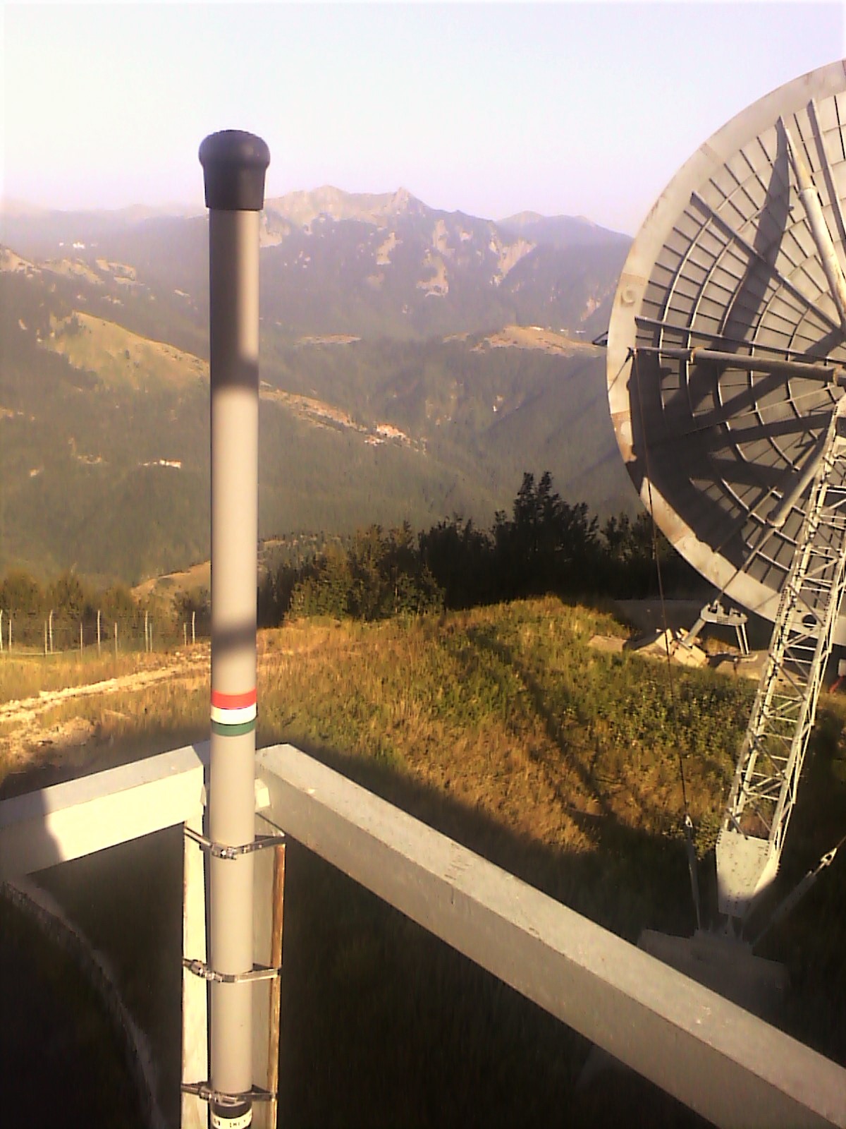
The detection of the natural electromagnetic field inside the magneto-ionospheric cavity is of great relevance for two reasons. On the one hand it is the basis of studies for a better understanding of the phenomena relating to the physics of the magnetosphere and the ionosphere, on the other it is the basis of the research of possible emissions of ULF-VLF signals coming from the internal structures of the Earth.
The frequencies of the investigated signals range from the lowest region of the spectrum where a network of magnetic sensors for ULF frequencies and detection stations for electromagnetic signals up to frequencies of 25 kHz is active. The effects of lightning, spherics, whistlers and tweeks also fall within this range, which are typical examples of electromagnetic emissions triggered by energy pulses inside the Earth-Ionosphere cavity.
The new Cassandra experimental network for electromagnetic monitoring in the VLF band joins the IRON network for monitoring radon gas in a systematic and comparative study campaign of seismic precursors which will also employ neural network algorithms. The network includes 4 sites distributed along the Apennines.
In laboratory experiments, on rocks subjected to rupture with uniaxial compression, monitoring of the very low frequency electromagnetic spectrum (ELF – VLF) highlighted the existence of impulsive electromagnetic emissions associated with the microfracturing necessary for the enucleation of the fracture. A similar emission process was also found on the limestone slopes immediately after the quarry fronts were demolished: this time under conditions of stress relief during the settlement process of the slopes. These experimental experiences give hope for the possibility of identifying very low-frequency electromagnetic emissions in nature spontaneously generated by the mechanical process of earthquake preparation. Basically it would be a precursor associated, like many others, with the dilatancy of the rock but in this case it would be a radiation generated directly and systematically by the dilatancy.
Therefore, the continuous monitoring of VLF electromagnetic radiation as a possible seismic precursor appears promising. However, as with any other precursory phenomenon, one must not be impressed by the name: in the current state of research, an operational use for the purpose of forecasting is not yet possible. The best strategy, on the other hand, is the comparative study of as many potential precursors as possible.
Radio signals in the VLF band have wavelengths of hundreds of kilometers. The active antenna used in the monitoring network is only one meter long and works as a field receiver of the electric field component only. The working band extends from 20Hz to 20kHz, with a smooth response in the range between 1 and 13kHz and sensitivity of 1μV. Monitoring occurs continuously at the sampling frequency of 44100 Hz, which is the same frequency used in music CDs.
The working band of the VLF monitoring stations corresponds to that of the acoustic frequencies and the electromagnetic signal, converted into an electrical signal, is analyzed through acoustic spectrograms or "sonograms".

THE MEDNET SEISMIC NETWORK (MEDITERRANEA NETWORK)

Figure 1 Map of the MedNet network stations, closed stations in red, operating stations in green.
Fig. 2 The tunnel where the instrumentation of the MedNet seismic station of Bardonecchia is installed (international code BNI).
The MedNet seismic network (Mediterranean Network) was born in the late 80s with two main objectives: to improve knowledge of the tectonic structure of the Mediterranean through the study of the source of strong and moderate earthquakes and to apply this knowledge to mitigate seismic risk in the region mediterranean. To these objectives must be added a more general but no less important one, the diffusion of broadband seismological culture in the region.
The MedNet project initially set out to install 12-15 broadband stations with a spacing of approximately 1000km. In 1988 the project was incorporated into the World Laboratory in Lausanne (Switzerland), an organization whose aim was to promote science in developing countries. The support of the World-Lab led to a rapid growth of the MedNet network with the establishment of scientific agreements with countries
North Africans and the opening of stations in Morocco, Algeria, Tunisia and Egypt. Over the past 15 years, the change in political conditions and the impressive technological development has led to an expansion of the prospects of the MedNet project which, while maintaining the two initial objectives unchanged, has expanded the area of interest to the Balkan region, a area affected by strong seismicity and with an important seismological tradition but poor in broadband seismic stations.
From the beginning, particular emphasis has been placed on the choice of sites, searching for mines, abandoned tunnels or sites in very remote places to enhance the qualities of the chosen seismometer, the Streckeisen STS-1, the best very broadband seismometer ever produced.
Over the years seismic noise analyzes have been performed (even retroactively) at MedNet stations, in particular through the spectral approach. At this link a database of power spectral diagrams (PSD) of acceleration noise at seismic station sites in the period 1994-2003 is available
Until the advent of real-time transmission systems for seismic data, data was exclusively recorded on site on magnetic tapes and sent by mail. This had the significant side effect of making maintenance of the station difficult, both due to the logistical and economic difficulty of reaching the site, and because months often elapsed between the breakdown, receipt of the magnetic tape and identification of the fault itself. A telephone connection with most of the sites guaranteed the possibility of downloading data "on demand" in the event of an earthquake and the Muscles automatic procedure in 1997 provided a rapid estimate of the magnitude of the Colfiorito earthquake after a few minutes.
Today, data transmission is ensured by a robust "real time" system which guarantees the usability of data in real time, the continuity of archived data and real-time monitoring of the stations.
Since its inception, the MedNet Project has been integrated into the Federation of broadband digital networks (FDSN), is a partner of IRIS ed ORPHEUS and, by distributing data to the international community quickly and automatically, it has contributed and continues to contribute to the study of seismology on both a global, regional and local scale.
Particular emphasis has been sought from the outset and continuously on the usability of the data by the foreign partners hosting the station in order to contribute with the MedNet station to their local seismic network and thus provide an additional tool for monitoring and the study of the seismicity of their country.
Today the MedNet network has 28 stations installed, of which 25 are operational, in 14 countries. The stations contribute to real-time monitoring of Italy and all host countries and are managed in collaboration with the following Institutes:
National Institute for Earth Physics, Bucharest, Romania
Dept. of Physics, Malta University, Malta
Geophysical Institute - Czech Academy of Science, Czech Republic
Institut National de Meteorologie, Tunisia
Geodynamics Institute – National Observatory of Athens, Greece
Bogazici University and KOERI, Turkey
GEOFON, GFZ German Research Center for Geosciences, Germany
NRIAG National Research Institute of Astronomy and Geophysics, Egypt
CNRST Center National pour la Recherche Scientifique et Technique, Morocco
Geophysical Institute - Bulgarian Academy of Sciences, Bulgaria
Seismological Center, Academy of Albania
University of Trieste and INOGS, Italy
CRAAG Center de Recherche en Astronomie Astrophysique et Géophysique, Algeria
Seismological Institute of Serbia
Montenegro Seismological Observatory, Montenegro
Seismological Institute of Banja Luka, Republika Srpska

MONITORING NETWORKS
National Seismic Network (RSN)
THE ALTO TIBERINA NEAR FAULT OBSERVATORY (TABOO)
National Integrated GPS Permanent Geodetic Network (RING)
Multiparameter networks of active volcanoes in Sicily
Multiparameter networks of active volcanoes in Campania
Ionospheric scintillation monitoring network.
Measurement networks of electromagnetic fields ULF-ELF-VLF