Attraverso indagini geoelettriche ad alta risoluzione è stata definita in 3D la struttura superficiale del sottosuolo della zona di Pisciarelli, l’area di maggiore emissione fumarolica e idrotermale dei Campi Flegrei.
Indagini geofisiche di tipo elettrico hanno permesso la realizzazione di una nuova immagine 3D della parte più superficiale del sistema idrotermale di Pisciarelli.
Utilizzando tecniche tomografiche ad alta risoluzione, un team di ricercatori dell’Osservatorio Vesuviano dell’Istituto Nazionale di Geofisica e Vulcanologia (OV-INGV) ha ricostruito la struttura del sottosuolo nella zona di massima emissione di gas del vulcano dei Campi Flegrei.
I risultati dello studio “The Pisciarelli main fumarole mechanisms reconstructed by electrical resistivity and induced polarization imaging”, realizzato nell’ambito del Progetto INGV ‘Pianeta Dinamico - Working Earth’ e della Convenzione B2 INGV-DPC 2019-2021, sono stati appena pubblicati nella rivista ‘Scientific Reports’.
Il campo fumarolico di Pisciarelli e la vicina Solfatara rappresentano, attualmente, il settore vulcanico più attivo della caldera dei Campi Flegrei sia per il flusso delle emissioni gassose che per l’attività sismica più recente.
Nell’ultimo decennio l’area di Pisciarelli ha mostrato notevoli cambiamenti morfologici testimoniati dall'apertura di nuove bocche fumaroliche, da variazioni nelle caratteristiche geochimiche dei fluidi e da alcuni episodi di emissione di fango. Di conseguenza, l'accesso all'area è stato già da tempo vietato al pubblico per motivi di sicurezza.
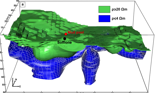
“Abbiamo effettuato indagini tomografiche ad alta risoluzione”, spiega Antonio Troiano, ricercatore dell’Osservatorio Vesuviano dell’INGV e primo autore della ricerca. “Dal modello 3D ottenuto da queste nuove indagini geoelettriche, abbiamo potuto ricostruire la struttura del sottosuolo nella zona di massima emissione di gas, contenente la fumarola principale (cd. “soffione”) e la pozza di fango che, nel tempo, si è modificata e ampliata”.
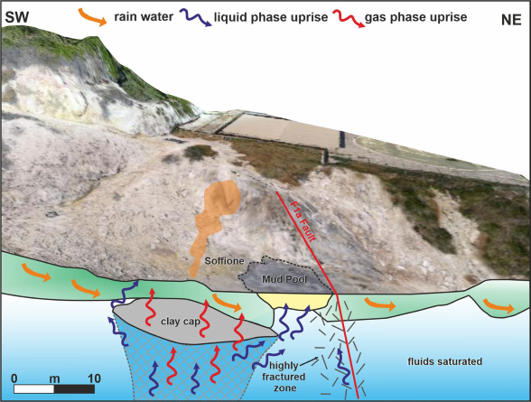
“In questa ricerca”, precisa Roberto Isaia, ricercatore dell’Osservatorio Vesuviano dell’INGV, “abbiamo evidenziato che la via principale di risalita dei fluidi avviene da un serbatoio più profondo attraverso un condotto, nella cui parte sommitale è presente una formazione di materiale argilloso. La geometria delle strutture rilevate fornisce informazioni fondamentali per chiarire i processi che regolano la circolazione dei fluidi e l'emissione di gas o vapori nell’area presa in esame”.
“Grazie all’alta sensibilità della resistività e della caricabilità elettrica nel rilevare la presenza di fluidi all’interno delle strutture sepolte”, continua Antonio Troiano, “è stato possibile realizzare il primo modello concettuale in grado di spiegare i meccanismi che governano l'attività emissiva del complesso di Pisciarelli”.
L’immagine 3D di Pisciarelli e il modello proposto rappresentano un significativo contributo scientifico per comprendere l’evoluzione dei fenomeni vulcanici in atto nell’area, per valutarne i rischi associati e per migliorare le strategie di monitoraggio di questo campo fumarolico.
Un contributo che potrà essere utile in futuro per affinare gli strumenti di previsione e prevenzione di protezione civile ma che al momento non ha alcuna implicazione diretta su misure che riguardano la sicurezza della popolazione.
Link:
---
A new 3D model of the subsoil of an area of Campi Flegrei
Through high-resolution geoelectrical surveys, the shallowstructure of the subsoil of the Pisciarelli area, the fumarolic field with most intense hydrothermal emission of the Campi Felgrei caldera, was defined in 3D.
Electrical geophysical investigations have allowed the reconstructionof a new 3D image of the most shallowerpart of the hydrothermal system of Pisciarelli.
Using high-resolution tomographic techniques, a team of researchers from the Osservatorio Vesuviano of the Istituto Nazionale di Geofisica e Vulcanologia (OV-INGV) reconstructed the structure of the subsoil in the area of maximum gas emission of the Campi Flegrei volcano.
The results of the study "The Pisciarelli main fumarole mechanisms reconstructed by electrical resistivity and induced polarization imaging", supported by the INGV Project 'Pianeta Dinamico - Working Earth' and the B2 INGV-DPC 2019-2021 Convention, have just been published in 'Scientific Reports' journal.
The fumarolic field of Pisciarelli and the nearby Solfatara currently represent the most active volcanic sector of the Campi Flegrei caldera both for emissions and more recent seismic activity.
In the last decade, the Pisciarelli area has shown significant morphological changes including the opening of new fumarolic vents, variations in the geochemical characteristics of the fluids and some episodes of mud emissions. As a result, access to the area has long been forbidden to the public for safety reasons.
"We carried out high-resolution tomographic survey", explains Antonio Troiano, researcher at Osservatorio Vesuvano, INGV, and first author of the study. "From the 3D model obtained from these new geoelectric investigations, we were able to reconstruct the structure of the subsoil in the area of maximum degassing, containing the main fumarole (so-called "Soffione") and the mud pool which, over time, has changed and expanded".
"In this research", explains Roberto Isaia, researcher of the Osservatorio Vesuviano, INGV, "we have highlighted that the main way of uprising fluids occurs from a deeper reservoir through a channel, surmounted by a clay-cap formation. The geometry of the detected structures provides fundamental information to clarify the processes that regulate the shallow fluids circulation and the emission of gases or vapors in the study area".
"Thanks to the high sensitivity of resistivity and electrical chargeability in detecting the presence of fluids inside buried structures", continues Antonio Troiano, "it was possible to create the first conceptual model capable of explaining the mechanisms that govern the activity emission of the Pisciarelli complex".
The new 3D image of Pisciarelli and the related conceptual model can help to understand the evolution of volcanic phenomena taking place in the area, to provide an evaluation of the associated hazards, and to better monitor the processes occurring in the Pisciarelli fumarolic field.
A contribution that may be useful in the future to refine the tools for forecasting and prevention of civil protection but which at the moment has no direct implication on measures concerning the safety of the population.
Link:

Fig. 1 – Rappresentazione grafica del modello 3D ottenuto tramite la tomografia di resistività elettrica.
Fig.1 - Sketches of the 3D resistivity model.

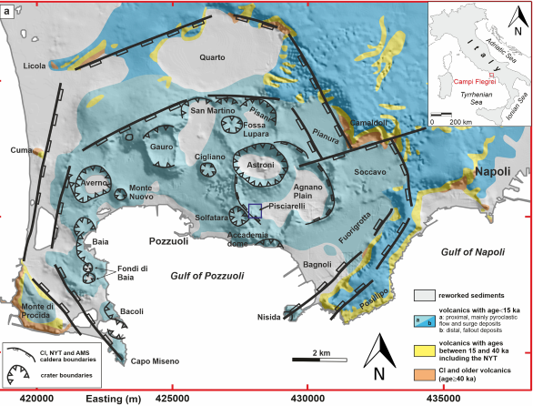
Fig. 2 - Mappa della caldera flegrea. Il rettangolo nero evidenzia la posizione del campo fumarolico di Pisciarelli, sede delle investigazioni geofisiche.
Fig 2 - Map of the Campi Flegrei caldera. The black box delineates the location of the PFF site.

Fig. 3 - Modello strutturale del campo fumarolico di Pisciarelli.
Fig.3 - Structural setting of the PFF feeding system.


