Una nuova analisi del rischio sismico nell'area del centro storico di Catania ottenuta con le stazioni della prima Rete Sismica Urbana d’Italia
Attraverso le 20 stazioni sismiche della prima Rete Sismica Urbana d’Italia, realizzata a Catania, sono stati monitorati alcuni edifici di carattere storico-monumentale della città siciliana durante il terremoto di magnitudo 4.3 dello scorso 23 dicembre 2021.
La Rete, che costituisce l’Osservatorio Sismico Urbano di Catania (OSU-CT), è stata sviluppata dall’Istituto Nazionale di Geofisica e Vulcanologia (INGV) nell’ambito del progetto PON eWAS “an Early WArning System for cultural heritage”.
Essa ha lo scopo di monitorare lo stato di salute delle strutture e delle infrastrutture cittadine, di sperimentare un sistema automatico di allarme rapido on-site per i terremoti, di valutare in tempi rapidi l’eventuale danno alle strutture attraverso la generazione automatica di mappe di scuotimento (shakemaps) e, infine, arricchire gli studi sulla microzonazione sismica del territorio.
“Il 23 dicembre scorso con il terremoto di Motta Sant’Anastasia (CT) di magnitudo 4.3 la rete dell’OSU-CT ha permesso un’analisi del rischio sismico particolarmente dettagliata sulla risposta all’evento delle strutture del centro storico di Catania”, spiega Domenico Patanè, responsabile del progetto. “La rete, infatti, è caratterizzata da un'elevata densità di stazioni sismo-accelerometriche, la maggior parte delle quali situate nel centro storico in corrispondenza di edifici di carattere storico-monumentale”.
“Le mappe di scuotimento (ShakeMap)”, prosegue il ricercatore, “forniscono un'immediata visualizzazione del livello di scuotimento di una zona colpita o interessata da un terremoto. L’INGV da diversi anni calcola le ShakeMap per i terremoti a partire di magnitudo 3.0. Esse riportano i valori di picco registrati dagli accelerometri e dai sismometri della Rete Accelerometrica Nazionale (RAN) del Dipartimento per la Protezione Civile e dalla Rete Sismica Nazionale (RSN) dell’INGV, presenti nella zona del terremoto”.
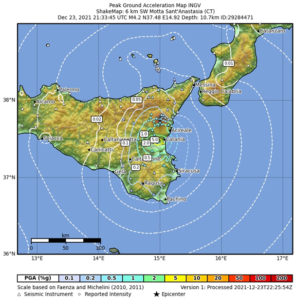
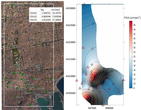
“Per il centro storico di Catania”, aggiunge Domenico Patanè, “l’elaborazione della mappa di scuotimento a scala urbana ha permesso di evidenziare come in alcune zone dell’abitato siano stati registrati maggiori risentimenti rispetto ai valori riportati nella mappa elaborata a scala più ampia che si riferisce alle osservazioni delle stazioni di rilevamento più vicine ubicate a Paternò e a sud della città nella Piana di Catania. Il maggior dettaglio ottenuto dall’OSU-CT è conseguenza proprio dei numerosi dati accelerometrici ricavati dalle stazioni della rete urbana”.
L’indicazione sul livello di scuotimento osservato, e quindi del potenziale impatto sugli edifici, rappresenta una informazione particolarmente utile alla Protezione Civile per il coordinamento e l’organizzazione delle squadre di soccorso nel caso di terremoti rilevanti.
“Altre 20 stazioni sismiche saranno collocate nei primi mesi del 2022 e ottimizzeranno l’attuale copertura del centro storico, estendendosi oltre la cintura comunale di Catania. Saranno inseriti, infatti, altri siti pilota in analogia a quanto già fatto per il centro abitato del porto dell’isola di Vulcano e il centro storico di Ragusa sviluppando la rete OSU nei territori a maggior rischio sismico ma anche vulcanico della Sicilia”, continua il ricercatore.
Gli investimenti volti all’incremento della resilienza dell’intero patrimonio costruito, con reti come la OSU, possono rappresentare un moderno e praticabile cambio di passo nella complessa problematica della mitigazione del rischio sismico e aiutare gli organi di governo all'adozione delle migliori scelte nelle politiche di prevenzione da adottare.
I recenti terremoti che hanno colpito centri urbani densamente popolati come quello dell’Irpinia nel 1980, dell’Umbria-Marche nel 1997, de L’Aquila nel 2009, dell’Emilia nel 2012 e di una vasta area del centro Italia del 2016-2017, hanno dimostrato che l’inconsapevolezza delle prestazioni sismiche degli edifici in cui si vive o si lavora e delle infrastrutture del territorio ha determinato il collasso delle comunità che, in alcuni casi, ha prodotto anche la distruzione di interi paesi.
“È con tale obiettivo”, sottolinea Domenico Patanè, “che è stata sviluppata una rete di monitoraggio a basso costo, potenzialmente applicabile in tutti gli edifici, costituita da sistemi standardizzati per il monitoraggio dinamico. Essa consente di acquisire informazioni utili alla valutazione della vulnerabilità e integrità delle strutture a seguito di un evento sismico. Tali stime, nell’ambito di eWAS, sono condotte in collaborazione con Ivo Caliò e Francesco Cannizzaro del Dipartimento Ingegneria Civile e Architettura dell’Università di Catania e Giuseppe Occhipinti del Consiglio Nazionale delle Ricerche istituto di Geologia Ambientale e Geoingegneria, IGAG-CNR, attraverso la modellazione numerica degli edifici monumentali e la loro calibrazione sulla base di modelli numerici avanzati.
È ovvio che conoscere lo “stato di salute” di una struttura (Structural Health Monitoring, SHM) in un territorio fortemente esposto al rischio sismico, consente di valutare ed adottare politiche di resilienza ben prima che un evento critico si verifichi, consentendo in tal modo non solo di ridurre e/o di ottimizzare gli investimenti ma, soprattutto, di ridurre le conseguenze associate all’evento”. Concludendo, afferma “Similmente, in uno scenario post terremoto, sistemi e reti di monitoraggio potranno consentire di ottenere utili informazioni per stimare rapidamente (quasi in tempo reale) il livello di danneggiamento degli edifici e delle infrastrutture (ponti, viadotti, ecc.), accelerando così la macchina della gestione dell’emergenza e riducendo i tempi di intervento e di ripresa”.
---
Historic buildings monitored with the Urban Seismic Network of Catania during the earthquake of 23 December 2021
A new seismic risk analysis in the area of the historic center of Catania obtained with the stations of the first Urban Seismic Network in Italy.
Through the 20 seismic stations of the first Urban Seismic Network of Italy, built in Catania, some historic-monumental buildings of the Sicilian city were monitored during the 4.3 magnitude earthquake on 23 December 2021.
The Network, which constitutes the Urban Seismic Observatory of Catania (OSU-CT), was developed by the Italian Istituto Nazionale di Geofisica e Vulcanologia (INGV) as part of the PON eWAS "an Early WArning System for cultural heritage" project.
It aims to monitor the state of health of the structures and city infrastructures, to test an automatic rapid alert system on-site for earthquakes, to quickly assess any damage to the structures through the automatic generation of maps of shaking (shakemaps) and, finally, enrich the studies on the seismic microzoning of the territory.
"Last December 23 with the 4.3 magnitude earthquake in Motta Sant'Anastasia (CT), the OSU-CT network allowed a particularly detailed seismic risk analysis on the response of the structures in the historic center of Catania to the event", explains Domenico Patanè, project manager. “The network, in fact, is characterized by a high density of seismic-accelerometric stations, most of which are located in the historic center inside of important historical-monumental buildings”.
“Shakemaps”, continues the researcher, “provide an immediate visualization of the shaking level affecting the area hit by an earthquake. The INGV has been calculating Shakemaps for earthquakes with magnitude higher of equal 3.0 for several years. They report the peak ground motion values recorded by the accelerometers and seismometers of the National Accelerometric Network (RAN) of the Department for Civil Protection and the National Seismic Network (RSN) of the INGV, deployed in the earthquake area".
"For the historic center of Catania", adds Domenico Patanè, "the development of the shaking map on urban scale has made possible to highlight how in some zones of the inhabited area greater resentments have been recorded with respect to the values shown in the map drawn up at a larger scale. The last are referred to the observations of the nearest survey stations located in Paternò and in the southern partof the city, that is in the Piana di Catania. The greater detail in terms of ground shaking obtained by the OSU-CT, is a consequence of the numerous accelerometric data obtained from the stations of the urban network".
The indication of the observed shaking level, and therefore of the potential impact on buildings, represents particularly useful information for the Civil Protection, for the coordination and organization of rescue teams in the event of significant earthquakes.
"Another 20 seismic stations will be located in the early months of 2022 which will optimize the current coverage of the historic center, extending beyond the municipal belt of Catania. In fact, other pilot sites will be included in analogy to what has already been done for the inhabited center of the port of the island of Vulcano and the historic center of Ragusa, developing the OSU network in the areas with the greatest seismic risk but also volcanic one in Sicily", continues the researcher.
Investments aimed at increasing the resilience of the entire built heritage, with networks such as the OSU, can represent a modern and practicable change of pace in the complex problem of seismic risk mitigation and help government bodies to adopt the best choices in prevention policies.
The recent earthquakes that hit densely populated urban centers such as the ones of Irpinia in 1980, Umbria-Marche in 1997, L'Aquila in 2009, Emilia in 2012 and the central Italy in 2016-2017, have shown that the unawareness of the seismic performance of the buildings and of the infrastructures has led to the collapse of entire communities.
"It is with this objective", emphasizes Domenico Patanè, "that a low-cost monitoring network has been developed, potentially applicable in all buildings, consisting of standardized systems for dynamic monitoring of structures. It makes possible to acquire useful information for assessing the vulnerability and integrity of structures due to a seismic event. These issues are conducted, inside eWAS project, in collaboration with Ivo Caliò and Francesco Cannizzaro of the Civil Engineering and Architecture Department of the University of Catania and Giuseppe Occhipinti of the National Research Council Institute of Environmental Geology and Geoengineering, IGAG-CNR, through numerical modeling of monumental buildings and their calibration on the basis of advanced numerical models.
It is obvious that knowing the "state of health" of a structure (Structural Health Monitoring, SHM) in an area highly exposed to seismic risk, allows to well evaluate and adopt resilience policies before a critical event occurs. Additionally, it allows to reduce and / or optimize investments and to mitigate the consequences associated with the event too". In conclusion, he states “Similarly, in a post-earthquake scenario, networks and monitoring systems will allow to obtain useful information to quickly estimate (almost in real time) the level of damage to buildings and infrastructures (bridges, viaducts, etc.), thus accelerating the emergency management machine and reducing intervention and recovery times".

Fig. 1 - Mappa (shakemap) delle accelerazioni di picco del suolo (Peak Ground Acceleration, PGA) dell’evento di magnitudo 4.3 registrato alle ore 21:33 (UTC) del 23 dicembre 2021 (http://shakemap.ingv.it/shake4/data/29284471/current/products/pga.jpg). Le isolinee riportano i valori di PGA in % g (accelerazione di gravità).
Fig. 1 - Map of the peak ground accelerations (PGA) of the 4.3 magnitude event recorded at 21:33 (UTC) on 23 December 2021 (http://shakemap.ingv.it/ shake4 / data / 29284471 / current / products / pga.jpg). The isolines report the PGA values in% g (acceleration of gravity).

Fig.2 – Ubicazione delle stazioni OSU nel centro storico del comune di Catania (sinistra) e mappa (shakemap) delle accelerazioni di picco del suolo (Peak Ground Acceleration, PGA) dell’evento di magnitudo 4.3 registrato alle ore 21:33 (UTC) del 23 dicembre 2021. Le isolinee riportano i valori di PGA in cm/sec². 1 g (accelerazione di gravità) = 980,665 cm/s². Nella tabella in alto a destra sono riportati alcuni valori di PGA (in %g e in cm/sec2) registrati a 3 delle stazioni di OSU-CT.
Fig. 2 - Location of OSU stations in the historic center of Catania (left) and relative map (shakemap) of the peak ground accelerations (PGA) of the 4.3 magnitude event recorded at 21:33 (UTC) of 23 December 2021. The isolines report the PGA values in cm / sec². 1 g (acceleration due to gravity) = 980.665 cm / s². The table on the top left shows some PGA values (in% g and in cm / sec2) recorded at 3 of the OSU-CT stations.

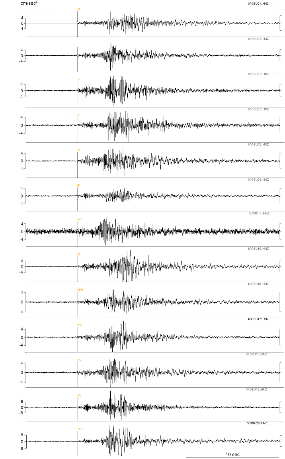
Fig. 3 - Registrazioni accelerometriche della componente verticale a diverse stazioni della rete OSU-CT.
Fig. 3 - Accelerometric recordings of vertical component at different stations of the OSU-CT network.


